 |
|
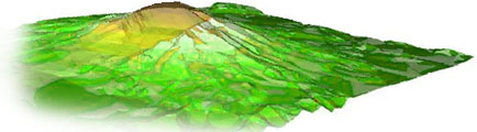
Analogous Landscapes II International Art Biennial-Buenos Aires Museo Nacional de Bellas Arte 2002 C5's research into the epistemic function of human cooperation continues with a new project that utilizes GIS (Geographic Information Systems) and GPS (Global Positioning Systems) technology. The proposed artwork takes form as a comparative analysis of Mt. Fuji in Japan and Mt. Shasta in California. Both are active volcanoes selected because of their cultural significance, topographic and visual similarity. (There are many analogous landscapes and the exhibition will include other examples.) The project was initiated at the Second International Art Biennial Buenos Aires in November of 2002 and will be completed in 2004. The first incarnation of the project involves the fabrication of two small sculptural models (25-cm diameter/12-14 cm height) of the topographical features of Mt. Fuji and Mt. Shasta. Each object is produced directly from DEM (Digital Elevation Data) obtained from the NASA/Jet Propulsion Laboratory and Japanese ASTER satellite topographic mapping projects. A computer controlled milling machine (CNC) is used for fabrication directly from the data source. The objects are in essence, actualized database objects. The installation includes supporting materials that contextualize the objectives and trajectory of the project. In 2004, C5 will enable two teams equipped with satellite telecom and instrumentation integrating GPS tracking and DEM terrain information to climb the mountains in an experiment of multi-site cooperation and navigation. The teams will ascend the mountains while deliberately maintaining identical elevation. To accomplish this task each team will select appropriate navigational paths in concert with the other. Custom software, support instrumentation and endurance gear will be designed to facilitate the objective of simultaneous ascent. The final exhibition will present all artifacts associated with the enterprise including the original Mt. Fuji and Mt Shasta data objects with the navigational paths engraved. |