|
|
|
|
|
 |
|
|
The Analogous Landscape: Expeditions
Hiking and mountaineering are dangerous and can result in serious injury or worse
Mt. Fuji Expedition July 11, 12, 2004
Mount Fuji is the archetype of the stratovolcano. The volcano rises 12,395 feet (3,776 m) above the surrounding plain. Stratovolcanos consist of explosively erupted cinders and ash mixed with lava flows. They form from a central conduit. The upper part is usually very steep (35 degrees) and contains loose rock. It may be almost impossible to climb safely on these steep slopes. Loose ash and cinders can make progress extremely difficult with one step up and two steps down marking the progress up the slope. There is also the danger of rockfall in the unstable environment. Mt. Fuji last erupted in 1707 when it ejected andesitic pumice blocks and created a new crater on the middle of its southeastern flank. The C5 team ascended by the Subashiri route.
The purpose of the expedition was to collect GPS navigation tracks of a 2nd ring of fire volcanic peak, Mt. Shasta, being the first on the transverse side of the Pacific, to develop inferencing techniques for navigation of terrains of similar characteristic.
A simultaneous climb was executed on Mt. Lassen in California by a stateside C5 team. The Lassen Peak volcano rises 10,457 ft. (3,187 m) above sea level.
|
|

|
|
|
Mt. Fuji summit - 7/12/04
Mt. Fuji summit attained (left). Mt. Fuji sunrise (right). |
|
|
|
|
|
|
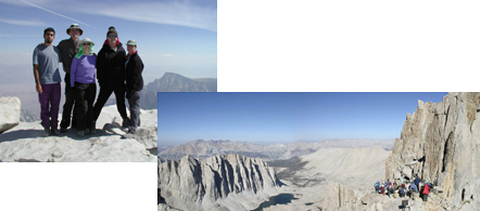
Mt. Whitney Expedition, October 4th and 5th, 2003
NAD217 38.0736/-119.382
C5 mounted its second climbing expedition to ascend Mt. Whitney in California, the tallest mountain in the contiguous United States at 14,491 ft. (4,417 m). It rises from the Owens Valley on the eastern border of the Sequoia National Park where it is situated amid a crowd of steep, formidable high granite peaks. Located on the east side of the Great Western Divide, a chain of mountains running north/south through California that include multiple peaks of altitudes over 12,000 ft. (3,657 m). Mt Whitney overlooks Death Valley, the lowest point in the United States, located only 85 miles to the southeast. The transformation bridging these two environmental topographies is dramatic. The summit trail is 10.7 miles (17.1 km) with an elevation gain of 6,136 ft. and rated with a difficulty of 5. It is a landscape punctuated with dramatic rock formations, steep ascents, dangerous cliffs and precipices. A large population of California black bear populates the region.
The objective of the expedition was to produce a coherent set of GPS navigation tracks for analysis, to experiment with documentation strategies and to develop high altitude climbing experience.
|
|
|
|
|
Mt. Whitney summit - 10/05/03
Mt. Whitney summit attained (left)/trailcrest summit approach (right). |
|
|
|
|
|
|
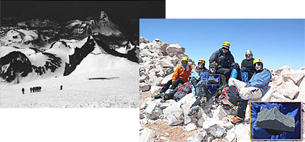
Mt Shasta Expedition June 8, 9, 10, 2003
NAD27 41.4094/-122.1939
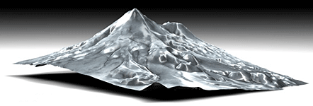
The Analogous Landscape Project began with the ascent of Mt. Shasta, a 14,162 ft. (4,137 m) volcanic mountain in the Cascade Range of North America. Mt. Shasta is located midway between the Pacific Coast and the Nevada border and is one of the largest Stratovolcanoes in the world. Mt. Shasta last erupted in 1786. It is a steep-sided, symmetrical cone of large dimension formed from alternating layers of lava, volcanic ash, cinders and rock blocks. It is the only mountain in California whose summit is above the snow equilibrium line on all sides. Mt. Shasta glaciers represent a significant water source to north central California in the dry season. Future eruptions of Mt Shasta are very likely from the vents at or near the summit. Geologic hazards include earthquakes, eruptions, flooding, landslides. The C5 Team ascended by the Avalanche Gulch Route.
The purpose of the expedition was to evaluate software for monitoring team members, test data visualization techniques and to conduct a variety of social cooperation experiments. A computer fabricated model of Mt. Shasta produced from DEM (Digital Elevation Data) was transported to the summit by the team and documented.
|
|
|
|
|
Mt. Shasta summit - 6/10/03
Mt. Shasta summit approach (left)/summit attained (right). |
|
|
|
|
|
|
|
 |
|
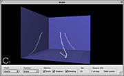
Mt. Shasta expedition - GPS data visualization
Computer graphic visualization of GPS data collected during a C5 climber's trek up Mt. Shasta. |
|